The Wandle Trail Heritage Walk
This map outlines the main points of historical interest on the Wandle Trail, which extends for almost 12 miles, from the Thames at Wandsworth, to the two sources of the river in Carshalton and Croydon. We have made every effort to ensure the accuracy of the map but the route is being constantly upgraded. Some alternative routes are also given. Be aware that sections of the walk are also shared with a cycle route.
Landscapes of History
Demands of the water-powered industries had a profound effect on the river as mills and workshops producing
copper and iron, oil, leather, paper, snuff and printed
textiles expanded. The Surrey Iron Railway, the first public railway, operated from 1803-1846. As industry
decreased, the river became associated more with
recreation and heritage. For more detailed descriptions of wildlife and the historical context please refer to the River Wandle Companion and Trail Guide (Steel & Coleman) and for a comprehensive guide to mills past and present go to Mills of the River Wandle (Saxby).
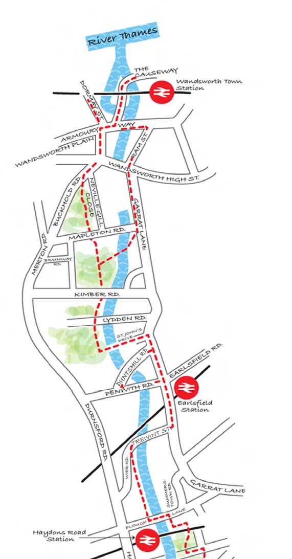
The Thames to Plough Lane
The Thames confluence can be viewed from the Spit, just off The Causeway. A plaque indicating the terminus of the Surrey Iron Railway (SIR) (1) is in the wall beside the lifebelt. Lower Mill straddled the river here. At Bell Lane Creek (2) note the bell and faint inscriptions over the sluice gate. The Armoury pub (formerly The Crane ) is opposite the site of Middle Mill, a “brazil” mill which ground dyestuff.
Route A – Stone sleepers from the SIR are in the wall of the
former Ram Brewery (3) on the right hand side of Ram Street side, removed during redevelopment in 2015. Cross Wandsworth High Street and note The Spread Eagle pub, where the SIR
contract was signed. Continue along Garrett Lane to rejoin the river as it emerges from under the shopping centre, site of the former Upper Mill. Cross Mapleton Road and continue to where the Wandle is joined by a cut emerging from beneath the former Royal Paper Mill . Follow the path to the right into King George’s Park.
Route B – Divert up Dormay Street for Wentworth House and former works, where beam engines were made for the Ram
Brewery. Cross Armoury Way into Wandsworth Plain which has early 18thC merchants’ houses. Take Buckhold Road and into King George’s Park passing at the entrance a memorial tree to the brewer Sir John Young.
Continue through the park, crossing several roads, and exit left over Foster’s Way Bridge and through Henry Prince Estate to
St. John’s Drive, right at Garrett Lane then right on to Duntshill Road to the mill of the same name (4), a former flock mill. Return to Garrett Lane, go under the railway, and right along Trewint Street to the site of the former Garrett Mills, which produced oil and linseed. Just before Plough Lane beyond the east bank of the river is the former Garrett Copper Mill.
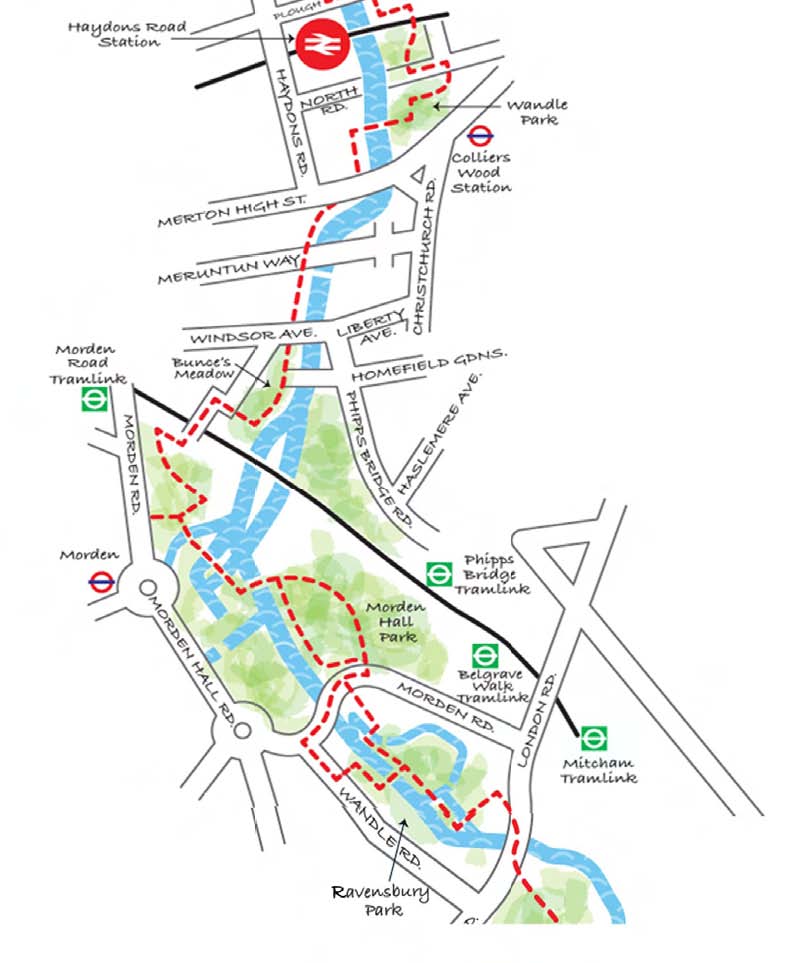
Plough Lane to Watermeads
After the confluence of the river Graveney go under the railway and sharp right into the Wandle Meadow Nature Park. Cross the park diagonally and walk under North Road. Take the footbridge over the river and turn sharp left along a path into the corner of Wandle Bank / Bygrove Road. Merton Mill (5) (now flats)
directly ahead, was built by John Rennie c.1789. The final mill owners were
Connolly Bros., leather dressers.
Route A – straight ahead along Wandle Bank to C19th Wandle Terrace cottages takes you alongside the cut made to serve the mill.
Route B – the original course of the river through Wandle Park was the
Wimbledon/Mitcham parish boundary.
The Pickle Ditch joins the Wandle at Merton High Street. Below the bridge to the shopping centre note the sign indicating the former location of William Morris’s works (6). The gateway at the end of the path is a replica but sections of the
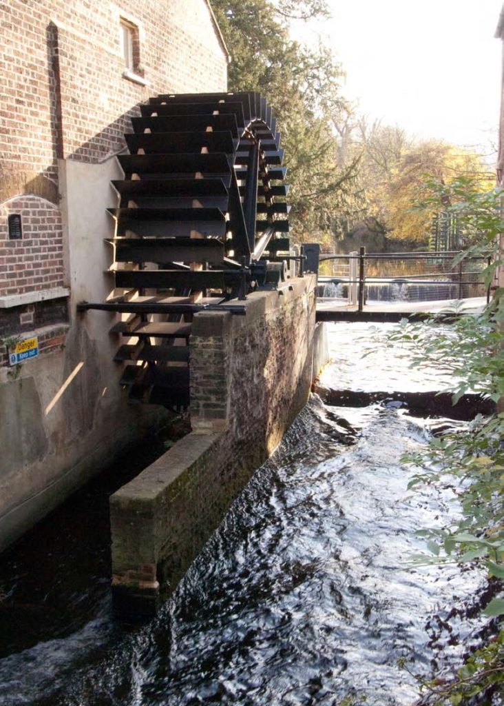
original Priory wall remain. The Roman Stane Street crossed the river near here and until the mid 1980’s this was a highly industrialised area originally served by its own railway sidings. The 12th century Merton Priory (7) lands extended from beneath the present shopping centre almost to Bunce’s Ditch. The remains of its Chapter House lie beneath Meruntun Way and are open occasionally. The Merton Abbey Mills (8) were the location of the Liberty Print Works until 1972. The water wheel is at present the only remaining fully operational wheel on the Wandle.
Calico bleaching fields existed on the west side of the river from Merantun Way as far as the present Deen City Farm. On the east side, the Pickle Ditch is taken through a sluice along the original course of the Wandle around the Priory and sections of the original Priory Wall can be seen.
As a diversion, cross the river just before the farm, then turn right into Phipps Bridge Road to see Everett’s Place cottages, with an attached Victorian folly, and Wandle Villa (1788) further on the right. Harland’s varnish works were also near here.
Morden Hall Park (NT) (9) has a snuff mill which operated until 1922. Follow signs at the white iron footbridge to divert to any of the NT properties such as Morden Lodge (c.1800). The river was divided into several channels during the
C 18th one of which served the Phipps Bridge Mills and one the Grove Field bleaching grounds. Exit the park, on to Morden Road, and note the 18th century White Cottage to your left. Ravensbury Mill (10) straddling the river at the park entrance opposite is a former snuff mill, possibly mid C17th containing 2 water-wheels as yet unrestored. Ravensbury Print Works (11) were important to the
development of fabric printing from late C 17th. Ravensbury ( Manor ) House (12) stood on the other side of a separate watercourse within the park where the
Mitcham to Morden road formerly crossed the river here until diverted mid C 18th. Both properties demolished mid C 20th. Mitcham Grove ( 13), was one of the finest houses in Mitcham and on slightly raised ground just west of Mitcham Bridge. A fragment of original wall exists to the north of the exit and a cedar tree survives beside the lake. A later Ravensbury Manor, now demolished, was built early
C19th for a Colonel Bidder.
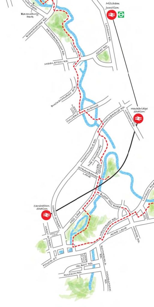
Watermeads to Carshalton
Beyond Mitcham Bridge lie the Watermeads(NT)(14), a nature reserve. A new path takes you round the northern edge along the riverside. Note the mid C 18th white weatherboarded cottages behind which is the former Grove Mill (Mitcham)(15) now flats, and the site of Morden Mill and Crown Mill, a possible workshop for the SIR . Through Watermeads runs Paper Mill Cut, containing the remaining millstones of Glover’s Mill but access to the sensitive wetland habitat is still not possible.
Just before Goat Bridge is a small terrace of C 19th cottages. The
embankment here is artificial (1960s) and only the mid C 19th mill house
remains from three mills including Deed’s Mill (Eagle Leather Works) (16). Bleaching grounds and former watercress beds are now within the factory estate. Cross Middleton Road to an interpretation board for the next section of river.
Continue through Watercress Park and on reaching Culvers Island the river divides. The remains of the wheelpit of Culvers Mill (17) can be seen by crossing the bridge to the island and the south side of Culvers Avenue and Millside (via Culvers Retreat).
Mullard’s factory was also just north of Culvers Avenue.
Cross Hackbridge/Nightingale Road and follow signs to Wilderness Island (18 ) where the two branches of the river meet and where Shepley and Hackbridge Mills were located. The walk now goes to Carshalton as the Croydon branch is inaccessible here. Continue along River Gardens to Mill Lane as far as Butter Hill Bridge.
Route A – Walk up Butter Hill Road for the short cut to Beddington Park.
Route B – Mill Lane to Carshalton
Above Butter Hill Bridge is Carshalton (Ansell’s) Mill (19) currently a print works. Follow the trail along Paper Mill Close crossing the river where indicated and into The Grove Park. Upper Mill (20) was converted to run two small generators. On reaching Carshalton Ponds an interesting diversion goes to Honeywood Heritage Centre (21) which has an excellent Wandle Room. After a wet season springs flow under the house into the western pond. The Water Tower (22) is open in summer. To see the former heads of the river cross the High Street and turn right at Carshalton Place and follow the Wandle Oaks link signs into Carshalton Park. The canal to the Grotto (23) and the Hogpit Pond (24) are now only filled after very heavy rain.
Carshalton Ponds to Beddington Park
Return to the west pond and enter The Grove turning right past the Council offices to the bowling green hut and bear left. Cross the Westcroft Canal, which served the (Carshalton) Grove Mill. Turn right in front of the Leisure Centre down to Westcroft Road. Cross Butter Hill towards Lon-don Road, where the short cut from Butter Hill Bridge joins up. Further up London Road was Wal-lington Mill, belonging to the C18th textile designer and printer William Kilburn. Walk alongside Elm Pond and cross London Road into Quinton Close. Turn left and walk along Lakeside over Derek Avenue, straight into Beddington Park via Manor Garden. Keep on the footpath to the left of the river crossing two small bridges along the way. The rockery is all that remains of Alfred Smee’s Victorian garden. Walk into the main park, keeping the large lake on your right and cross the small flint bridge. Continue straight on and after St. Mary’s Churchyard turn left on to Church Lane. Walk past Carew Manor (25), which has a Tudor Great Hall, and cross Canon Bridges’ Bridge. Turn right, past the Riverside Animal centre, turn right over the bridge and then left over the small car park. Continue on the diagonal path and follow the river to the exit at Guy Road where there is another interpretation board.

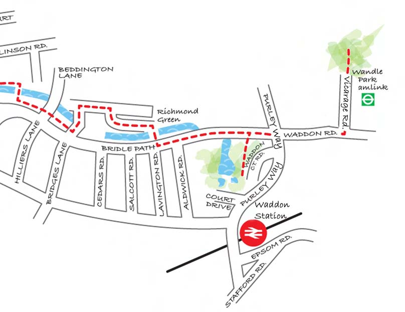
Beddington to Wandle Park
Cross Hilliers Lane and take the riverside walk to Bridges Lane noting waterside mill cottages known as Mount Pleasant (1884). (26) Lambert’s (Beddington) Mill (27) ahead, dating back to the
Domesday Book, remained a corn mill until converted to a snuff mill in the C18th. Turn left then first right on Kingston Gardens, following the river along Richmond Green then right over the bridge by the waysign to Lavington Road. Continue along the bridleway to Waddon Ponds. Until recently this remaining
spring-fed pond marked the first surface appearance of the Wandle. However, due to recent regeneration at Wandle Park the river now emerges from a culvert at its eastern end. To reach the park, continue east along Mill Lane crossing Purley Way into
Waddon Road, then left up Vicarage Road to cross the tramline into the park.
This Guide has been produced by
The Wandle Industrial Museum,
Vestry Hall Annexe, London Road,
Mitcham, Surrey
CR4 3UD
Tele No: 020 8648 0127
E-Mail: office@wandle.org
Web Site: www.wandle.org
© Wandle Industrial Museum 2015
Please Note:
Every effort has been made to ensure the accuracy of this guide. At times due to continued development and work along the river you may not be able to access certain parts of it.